Google Earth Image Shows Massive Alien Face In Antarctica
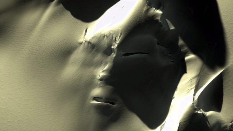
Millions are familiar with the face on the surface of Mars photographed in the red planet’s Cydonia region, but official explanations leave much to be desired and many wondering whether if it’s an artifact from an ancient civilization. But now there is a new face to ponder — one revealed from the melting ice of our planet’s frozen South. What’s being referred to as the “Antarctica Face” is causing quite a commotion among UFO hunters, skeptics, and scientists.
Antarctica Aliens or the Remnants of an Ancient Civilization?
The alien face of Antarctica is a sight to behold. It was discovered by Blake and Brett Cousins, who operate the YouTube channel “Third Phase Of Moon.” The pair has become extraordinarily successful as UFO hunters who frequently scan Google Earth for alien images captured from outer space. The brothers have amassed an impressive following over the years with their videos and commentary on UFO sightings and other strange phenomena, that is also reflected on their Facebook page boasting more than 750,000 followers. As of the first week of September 2019, their video on the Antarctica face alone (originally published on August 20, 2019) already received more than 350,000 views.
The Cousins’ mission, according to their Facebook description, is “to bring unfiltered video, messages & research in the field of ufology directly to the public!” The video of the Antarctica Face is certain to bolster their success and fan base, as well as bring attention to what is already a growing and well-established center of speculation.
In the Cousins’ video of the strange satellite images, Blake states, “It appears to be a massive, ancient structure of some kind of face that is being revealed for the first time on Google Earth.”
The Cousins’ YouTube video is captioned “Grey alien face captured in Google Earth map in Antarctica,”as there are clearly facial features that resemble an eye (with the possibility of the second eye just below the snowy landscape), a nose, and a mouth. Above the face may be a helmet.
Although interest in the Antarctica giant face in the mountains is growing by leaps and bounds, the image is actually not new. The satellite depiction by Google Earth was originally recorded on September 28, 2012, in the Admiralty Mountains not far from Daniell, Hallett, and Adare Peninsulas on the USA’s McMurdo Station side of Antarctica, as noted on the website of famous UFO researcher Linda Moulton Howe. “The McMurdo Station,” the website noted, “is a United States Antarctic research station on the South tip of Ross Island, which is in the New Zealand-claimed Ross Dependency on the shore of McMurdo Sound in Antarctica. The half-mile-long alien face is in the Admirality Mountains at the latitude/longitude upper right between Adare and Hallett Peninsulas.”
A Giant Face or Pareidolia?
Of course, skeptics are always quick to point out that the face is merely a product of erosion, which only looks human because our brains developed to see such things — much like seeing faces in the clouds or interpreting meaningful imagery out of a Rorschach test. The technical term for this is “pareidolia” and is the effect that causes the mind to interpret shapes, structures, and patterns as images that seem familiar.
Live Science explains, “There are a number of theories as to the cause of this phenomenon. Experts say pareidolia provides a psychological determination for many delusions that involve the senses.
Google Earth Mysteries waiting to be seen
The coordinates for the giant face in the snow, that is but one of many google earth mysteries, are 72°00’ 36.00’’ S, 168° 34’ 40.00’’ E, and several Google Earth enthusiasts have suggested that the alien head is about 3520 ft long.
One writer noted, “Sporting what seems to be a proportionate set of eyes, a nose, and a mouth, the eerie ‘visage’ has captured the imagination of conspiracy theorists who contend that Antarctica is home to all manner of esoteric secrets. Numerous observers were quick to note that the potential face bears an uncanny resemblance to the famed ‘Face on Mars’ that is said to sit in the Cydonia region of the Red Planet and was first photographed by NASA’s Viking 1 back in 1976.”
Curiosmos, explained, “Antarctica has become a repository for conspiracy theories, leading many people to speculate about the true nature of the frozen continent. One of the most famous conspiracy theories concerning Antarctica is the alleged, supermassive, snow-topped pyramids lurking in ‘plain sight.’ These alleged structures – which geologists say are no more than natural formations — are said to be the remnants of extremely ancient civilizations that inhabited Earth before our ‘civilization’ came into existence.”
Scientists have reported that Antarctica has lost nearly 3 trillion tons of ice since 1992, and it could very well be that the thaw is beginning to put the frozen South in a new light. Will we start to see more remnants of an ancient civilization as more ice melts?
Did Giant Exist? The Real History of Giants Living on Earth

Humans have long expressed a fascination and fear around the question, “Were there giants on Earth?” Whether in legends or life, giants have been worshipped, reviled, ostracized, and celebrated. Stories of towering beings appear in cultures around the world — from mythology to religious texts — and continue to capture our collective imagination.
While the existence of dinosaurs is backed by extensive scientific evidence, and millions journey to witness massive ancient monuments, the idea that actual human giants — beings over 20 feet tall — once roamed the earth is not supported by any credible scientific evidence. Despite popular claims and persistent folklore, no verified remains, fossils, or historical records confirm the existence of such beings.
That said, the enduring belief in giants raises a compelling question: What were people seeing — or experiencing — that led to these widespread legends? Though giants may not have existed in the literal sense, their presence in stories, symbols, and artifacts points to deeper cultural, psychological, and perhaps even natural explanations worth exploring.
Proof of Giants Throughout History
The concept of giants has been a part of human folklore and mythological narratives for millennia, resonating through various cultures and continents, from the Americas to Africa and from ancient Israel to the Norse. In the Americas, both North and South have indigenous legends speaking of giant beings, some even overlapping with interpretations of megafauna like mastodons that once roamed the land. The Native American tales often include references to a race of giants, which could be considered a cultural memory of these large prehistoric animals.
In Biblical Text
The biblical references, such as those found in the Book of Genesis, speak of the Nephilim, who are often portrayed as giants or mighty warriors and described as the offspring of the “sons of God” and the “daughters of men”. Nephilim have been subject to much interpretation, with some considering them metaphorical giants while others believe in their literal existence. David’s battle against Goliath is one of the most iconic stories of a human overcoming a giant from the Bible.
Around the World
From Africa to Germany, as well as in the Norse traditions of Europe, tales of giants are common, often tied to the creation myths and early histories of peoples. Native American folklore across various tribes frequently speaks of giants, who are depicted as powerful spirits or ancestors that roamed the land, some of whom interacted with the people, teaching or challenging them. In Egyptian mythology, the giant Geb, the god of the Earth, was often depicted as a colossal figure whose laughter was believed to cause earthquakes and whose body formed the hills and valleys of ancient Egypt. Perhaps no culture is more richly intertwined with tales of giants than that of the Greeks, from the gods of Olympus to their offspring, such as the Cyclops.
Giant Skeletal Remains
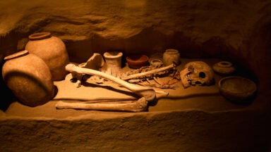
The Smithsonian Institution in the United States, along with other scientific bodies, has been involved in the study of large humanoid bones that have been discovered, often shrouded in mystery and sometimes labeled as hoaxes. Newspaper articles from the 19th and early 20th centuries in New York and California frequently featured stories of giant skeletons unearthed, fueling speculation about ancient giants on Earth.
Extraterrestrial Theories
Theories about ancient aliens, as seen in various full episodes of Beyond Belief or popular documentaries, sometimes suggest that these giants were extraterrestrial visitors, while others propose that they were simply larger human beings that lived in ancient times.
Skepticism remains high, with many of these stories considered hoaxes or misinterpretations of archaeological findings. The search for evidence continues, with enthusiasts combing through books, historical newspaper articles, and religious texts like the Christian Bible and the Book of Enoch for clues.
Scientific Constraints: The Square-Cube Law
Despite the richness of folklore and speculation, biology and physics place hard limits on the plausibility of giants as described in myths. One critical constraint is the square-cube law — a principle in biomechanics that explains why extremely large human-like beings could not physically exist. As a creature’s size increases, its volume (and therefore its mass) grows faster than its surface area. For humans, this means that as height increases, the weight increases exponentially — but the strength of bones and muscles, which depends on cross-sectional area, does not scale at the same rate.
In practical terms, a human scaled up to 20 feet tall would weigh many times more than their skeleton and muscles could support. The heart and circulatory system would also be unable to efficiently deliver oxygen through such a large body. This fundamental law of nature makes the existence of towering humanoid giants biologically unfeasible — regardless of stories or legends to the contrary.
Modern Giants, A Brief Look at Gigantism
Merriam-Webster defines a giant as being a “legendary humanlike being of great stature and strength,” as well as “a living being of great size.” In physical terms, a giant is a person over seven feet tall with a condition known as “gigantism.” The tallest person documented in modern history was Robert Wadlow (1918-1940), known as the “Alton Giant,” or the “Giant of Illinois,” who stood 8 feet 11 inches tall.

Robert Wadlow, the Alton Giant
Wadlow intended to study law but lived as a celebrity after traveling with the Ringling Brothers Circus and as a spokesman for giant-sized shoes. He died at a young age, an all too common end for those with gigantism — their weight and size put constant strain on the heart and skeletal system.
Today, genetic giants are gaining acceptance because, overall, humans have evolved into a taller species. According to Max Roser, an economist studying global standards of living conditions, between 1810 and 1980, European male height grew from an average of 160 centimeters to 185 centimeters. But despite this acceptance, giants can still find life in a normal-sized world stressful and lonely and, like Wadlow, are treated as an oddity. This contradiction doesn’t exactly mirror how giant races have been regarded throughout history.
Were there Giants on Earth?
In the realm of archaeology and anthropology, there is no credible evidence to suggest that a race of giants once roamed the Earth. Large bones often claimed to be from giant humans are usually identified as remains of prehistoric animals such as dinosaurs or mammoths.
However, tales of giant humans across the earth, whether rooted in mythology, religion, or speculative history, continue to intrigue us. From America to Africa, and from the annals of the Smithsonian to the pages of the Christian Bible, the concept of giants weaves a complex tapestry of intrigue, belief, and scholarly curiosity. Whether these stories emerge from real giants or are simply metaphors within cultural histories, they remain a compelling part of our collective narrative.

